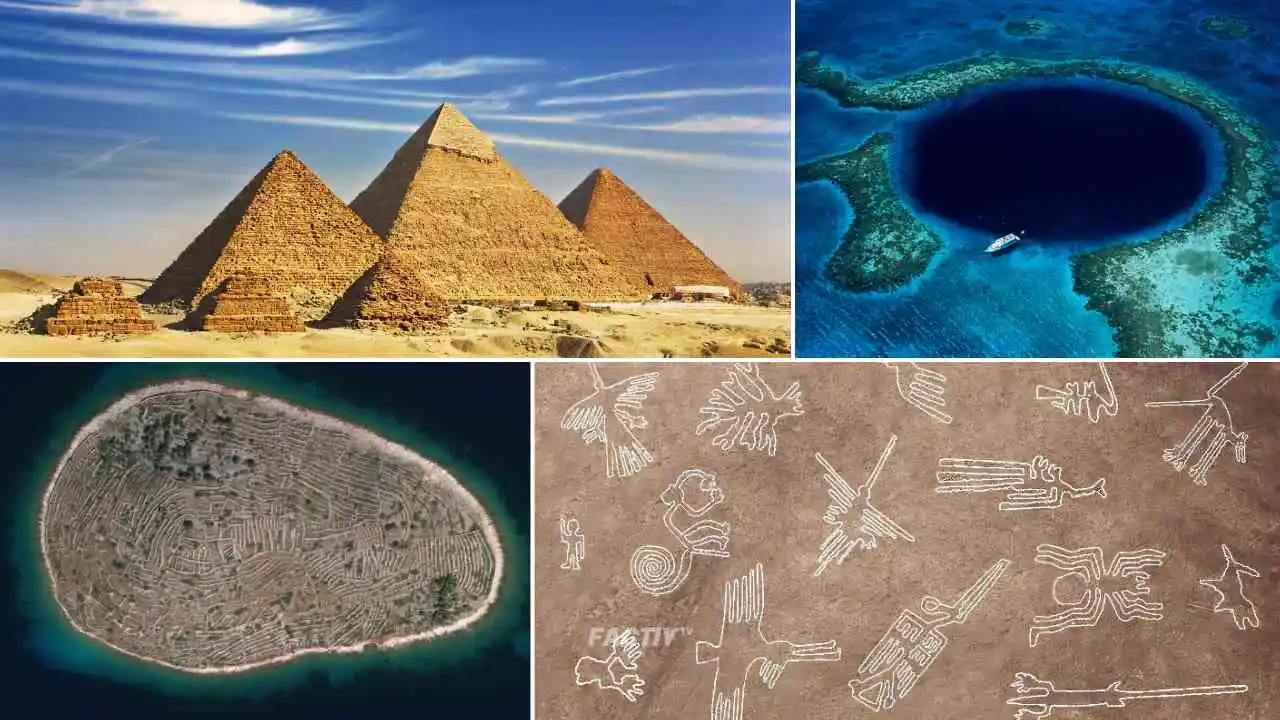
Friends, no one will deny that our earth is a treasure trove of mysterious and strange places. From terrifying scenarios to strange structures exist in our earth, about whose secrets even our scientists do not have any solid evidence. So friends, join us as we uncover stories and mysteries of some select hidden mysterious places in our world that are beyond explanation. So let us tell you through this article the world’s Top 15 Weird and Mysterious Spots on Google Earth.
1. Baljenac Island, Croatia

Baljenac Island, also known as Bavljanac Island, is a small island in the Sibenik archipelago of Croatia, situated along the coast of the city of Sibenik. The island spans approximately 14 hectares and is entirely covered by a complex network of over 23 kilometers of dry stone walls. Historians attribute the construction of these walls to 19th-century farmers from the neighboring island of Kaprije, who created them by hand, devoid of modern machinery or equipment, for agricultural purposes. Notably, when viewed from above, the intricate patterns of these dry stone walls give Baljenac the appearance of a colossal fingerprint. This distinct landscape has elevated Baljenac Island to a prominent tourist destination, and in 2018, it was bestowed with UNESCO World Heritage Site status.
[adsense_big123_code]
2. Spotted Lake, Canada

Spotted Lake is a saline endorheic alkali lake located northwest of Osoyoos in the eastern Similkameen Valley of British Columbia, Canada. There is no concrete evidence of the origin of Spotted Lake, but it is said to have been constructed during World War I to store minerals and ammunition. The spotted lake is a storehouse of various types of minerals, magnesium sulphate, calcium and sodium sulphate along with eight other minerals are found in abundance in it. But silver and titanium are found in less quantity. This lake is also considered as a sacred site providing medicinal waters.
3. The Great Blue Hole, Belize

The Great Blue Hole is a massive marine sinkhole off the coast of Belize. It is located near the center of Lighthouse Reef, a small atoll 43 miles from the mainland and Belize City. The hole is circular, 1,043 feet wide and 407 feet deep, covering an area of 760,500 square feet. It was formed during several phases of Quaternary glaciation, when sea levels were much lower. Analysis of stalactites found in the Great Blue Hole suggests that the formation took place 15,000 years ago. Later, as the sea began to rise again, the cave was flooded. The Great Blue Hole is a part of the larger Belize Barrier Reef Reserve System, which is a UNESCO World Heritage Site.
4. Adam’s Bridge (Ram Setu), India
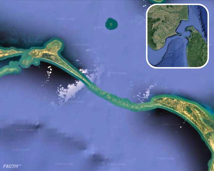
Adam’s Bridge, also known as Ram Bridge or Ram Setu, spans 48 kilometers (30 mi) and is believed to have been constructed about 18,400 years ago. It is a natural limestone bridge located on Pamban Island, also known as Rameshwaram Island, off the south-eastern coast of the Indian state of Tamil Nadu, between India and Sri Lanka. The special thing about this bridge is that it is floating on water, hence it is also called a floating bridge. Geological evidence suggests that the bridge was once a land connection between the two countries. However, according to mythology, it is attributed to Lord Shri Ram, who built the bridge to save his wife Sita Mata from Ravana through his soldiers Nala and Neel. The true origin of the bridge still remains a mystery.
Suggested Read : Boosting Knowledge: Top 15 Must Read Science Books of All Time
5. Lake Hillier (Pink Lake), Australia
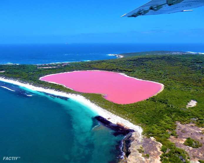
Hillier Lake is a brackish lake on the shore of Middle Island, located in the Goldfields-Esperance region of Western Australia. It is particularly notable for its pink colour. A long and thin strait separates the Southern Ocean from the lake. The length of this lake is about 600 meters and width is about 250 meters. It is believed that the pink color of this lake is due to the presence of an organism called Dunaliella salina, due to which it is also known as the Pink Lake. On 15 January 1802, Matthew Flinders, a British sailor, visited Lake Hillier for the first time. Flinders’ journal entries are considered to be the first written record of the lake. This lake still remains mysterious, whether it was created by a person or formed through a natural phenomenon.
[adsense_big123_code]
6. Marree Man, Australia

The Merry Man, also known as Stuart’s Giant, is a modern geoglyph discovered in 1998. It depicts an indigenous Australian man hunting with a boomerang or stick. It is located on a plateau near Finniss Springs, 60 km west of Marree Township in central South Australia. The figure is 2.7 km long with a circumference of 28 km, spread over an area of approximately 620 acres. Although it is one of the largest geoglyphs in the world, its origins remain a mystery, with no one claiming responsibility for its creation. It is also known as Top 15 Weird and Mysterious Spots on Google Earth.
7. El Ojo (Floating Eye), Argentina
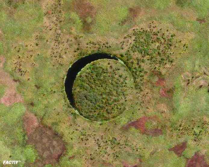
El Ojo, which translates to ‘The Eye’ in Spanish, is an uninhabited, circular floating island situated within a large, circular lake in the Paraná Delta of Buenos Aires Province, Argentina. The island earned its name due to its eye-like appearance when viewed from above. With an approximate diameter of 118 meters, it’s gradually shrinking due to erosion. This island garners global fame for its floating nature and stands out for its near-perfect circular shape. However, it constantly rotates on its axis due to the river’s flow beneath it. The exact formation date and process of the island remain unknown, with its first documented appearance in Google Earth imagery dating back to 2003.
8. Nazca Lines, Peru
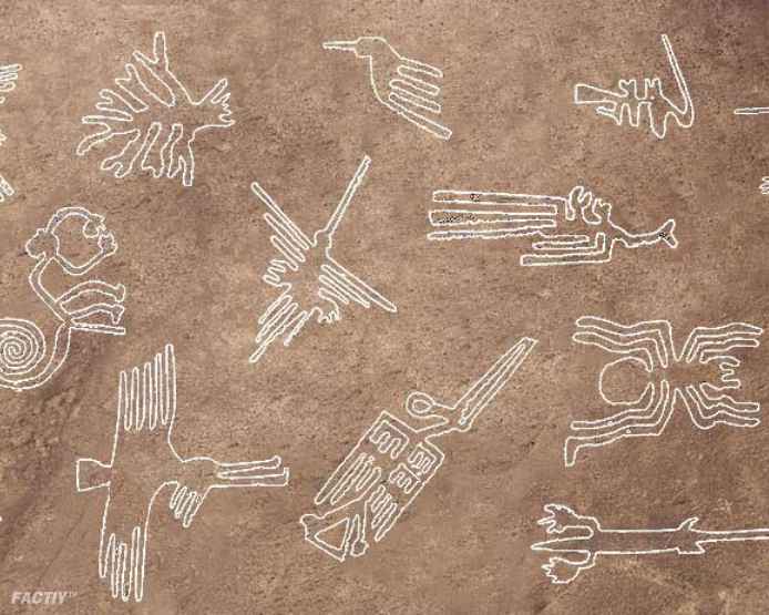
The Nazca Lines are a set of clay geoglyphs in the Nazca Desert in southern Peru. Historians believe that it was built by the tribes living in the Nazca desert before 500 BC. The Nazca Lines have two major phases, the first Paracas Phase, from 400 BC to 200 BC, and the second Nazca Phase, from 200 BC to 500 AD. Between 80 and 100 new figures have been found to date, and archaeologists believe there are still more figures to be found. This Guddi has not been solved yet whether these lines were made by humans or by Elinus, it still remains a mystery. In 1994, the Nazca Lines were declared a UNESCO World Heritage Site. This spot is also known as Top 15 Weird and Mysterious Spots on Google Earth.
9. The Great Pyramids of Giza, Egypt
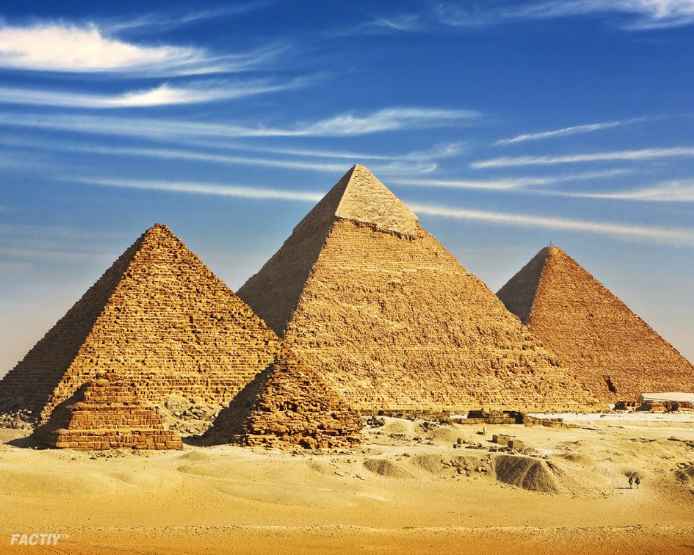
The Great Pyramids of Giza are one of the most iconic and impressive structures ever built. Located in Cairo, Egypt, three pyramids were built as the tombs of the pharaohs Khufu, Khafre and Menkaure. Apart from these three pyramids, several smaller pyramids also exist. The Great Pyramid of Giza is the largest pyramid in Egypt. They were built in the 26th century BC, over a period of approximately 27 years. This pyramid is counted among the seven wonders of the world. It is the most famous monument of the Giza pyramid complex, which is part of the UNESCO World Heritage Site. These pyramids remain mysterious and astonishing even today, some historians believe that these pyramids were built by aliens.
[adsense_big123_code]
10. Rujum El-Hiri, Israel
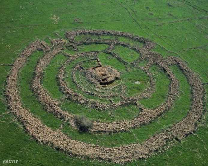
Rujm al-Hiri is an ancient megalithic monument consisting of concentric circles of stone with a central tumulus. Its name, ‘Rujm al-Hiri,’ meaning ‘stone heap of the wild cat,’ comes from Syria. Located in the Israeli-occupied part of the Golan Heights, it lies within a vast plateau decorated with numerous dolmens, about 16 kilometers east of the coast of the Sea of Galilee. Consisting of over 42,000 basalt rocks arranged in concentric circles, it consists of a central mound that rises to a height of 15 feet, with some circles complete and others incomplete. Historians believe that this monument dates back to the Bronze Age, about 5,000 years ago. However, it would be difficult to tell who built this monument and why, and the purpose behind its construction remains a challenging mystery.
Suggested Read : Top 15 Mysterious Science Experiments in History
11. Pentagram, Kazakhstan
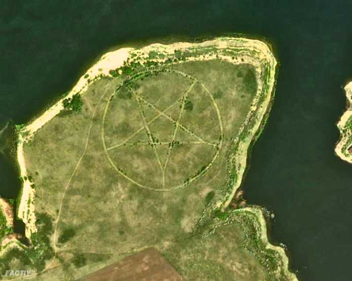
The Pentagram is located on the southern bank of the Upper Tobol Reservoir in Kazakhstan, a country in Central Asia. A large pentagram is inscribed on the Earth’s surface, which when viewed from the sky forms a star-like shape within a circular outline. This distinctive feature is clearly visible on Google Earth. There is no sign of human habitation around this area, the nearest human settlement being the town of Lisakovsk, about 12 miles to the east. The area around Lisakovsk is rich in ancient archaeological ruins. The originator of this mysterious figure and the purpose behind its creation are still shrouded in mystery.
12. Ushtogaysky Square, Kazakhstan

The Steppe Geoglyphs is located in the Turgai region of northern Kazakhstan. In this area, there are various types of earthen figures which have been dug out of the ground, which are at least 260. Some of these are small and some are big, the most important of which is Ushtogaysky Square. These shapes are made of square, ring and three other shapes. It is difficult to say when they were made, however, using optical dating, it has been determined that these figures date back to around 8000 BC.
13. Bermuda Triangle, North Atlantic Ocean

The Bermuda Triangle, also known as the Devil’s Triangle, is situated in the western North Atlantic Ocean, where numerous aircraft and ships are believed to have vanished under enigmatic circumstances. It covers an area spanning 700,000 square kilometers. The Bermuda Triangle has remained an enduring enigma, eluding conclusive explanations despite extensive research. Within this region, numerous ships and aircraft have indeed mysteriously disappeared. This place is also known as Top 15 Weird and Mysterious Spots on Google Earth.
[adsense_big123_code]
14. North Sentinel Island, India

North Sentinel Island is one of the Andaman Islands, an Indian archipelago in the Bay of Bengal that also includes South Sentinel Island. This island is home to the Sentinelese people, who prefer to live isolated from the world. The island is approximately 5.0 miles long and 4.3 miles wide, and has an area of approximately 23 square miles. The Andaman and Nicobar Islands prohibit any travel to the island and going closer than 5 nautical miles under the Indigenous Peoples Protection Act 1956. This area is protected by the Indian Navy and the Government of India.
15. Sailing Stones, Death Valley, USA

Sailing Stones, which are known by many names such as sliding rocks, walking rocks, rolling stones or moving rocks. These stones are found in a desert located in California which is known as ‘Death Valley’. These stones weigh approximately one quintal each or even more, although till date no one has seen these stones moving, but from the marks that have been found, it can be inferred that it must have been like this. Scientists believe that this is part of a geological phenomenon, in which stones move from one place to another due to high-speed winds. After research, it was revealed that the wind blows at a speed of 90 miles per hour in the desert and the snow that freezes at night and the thin layer of wet soil on the surface, all these together would make the stones move.
So this was the most Top 15 Weird and Mysterious Spots on Google Earth. Hope you find this information interesting and good, then do not forget to share this blog with your friends and relatives. And thank you very much for reading the blog till the end. Keep Reading…. Keep Sharing…. Keep Safe….!
Now you can also send us by writing a blog. to send click here
You can also purchase this product.
[aft_ads_code]

